April 05, 2005
Google's Bird's-Eye View: See Before You Go
Information Design and Data Visualization
Search Tools and Technologies
Have you ever wanted to see a place before you actually went there?
A far-away house?
A shopping-mall?
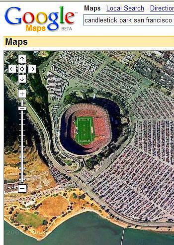
A stadium?
If you live in the US, now you can.
Google has just incorporated the amazing Keyhole satellite visualization technology into Google Maps and Google Local.
Now, when you type an address into Google Maps, you can click the 'Satellite' link and see a direct view of the area.
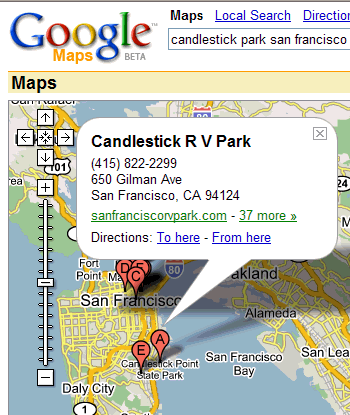
You can zoom, move the view by dragging, and even resize the window just like you can do in the normal 'Maps' view.
If you are in the US you can type in an address for an area where you have fund an ad in the paper and look at what kind of buildings are there. Where is the closest park? Is there a parking lot nearby?
If you are planning your journey down along the coast on route 1, you can now check motels and off-road sight-seeing spots with the clarity of an eagle.
You can even see driving directions superimposed on the real satellite imagery.
Google says on its announcement page:
"We can't promise you'll never miss another freeway exit, but we do think that Google Maps + Keyhole gives you a great way to see and explore your world."
Take a look and let me know what you think.
posted by Robin Good on Tuesday April 5 2005
Premium Reference
sponsored by
- Pings and Trackbacks
- Readers' Comments
- Related Articles
- Recommended Books
- Commercial Research Reports
- Search for more
Pings and Trackbacks
TrackBack URL for this article:
Readers' Comments
Related Articles
Watch The World From The Sky: KeyHole
I am really impressed. I have just downloaded, installed and tested out for a few minutes Google's new acquisition which is getting headlines everywhere. KeyHole, this is the name of this Windows-only software, is a powerful image navigation device leveraging a world-over scenery of satellite imagery covering the whole planet. Not only, KeyHole integrates an extraordinary amount of data relative to roads, borders, cities, and down to gas stations, pharmacies... read more
October 29, 2004 - Robin Good
Blinded Skies: Government To Close Access To Satellite Images
Big Bro to close our eyes to (and from) the skies? A yet to approved Senate bill would provide the ability to the US Government to basically put off limits all of the images coming off from research and monitoring satellites. "Nondisclosure of Certain Products of Commercial Satellite Operations," would exempt from the Freedom of Information Act (FOIA), unclassified, commercial satellite pictures bought up by the government, as well as... read more
September 11, 2004 - Robin Good
Gallery of Data Visualization - The Best and the Worst
http://www.math.yorku.ca/ SCS/Gallery/ = worth knowing Online Visual resource FREE "This Gallery of Data Visualization displays some examples of the Best and Worst of Statistical Graphics, with the view that the contrast may be useful, inform current practice, and provide some pointers to both historical and current work. We go from what is arguably the best statistical graphic ever drawn, to the current record-holder for the worst. Like good writing, good... read more
April 30, 2003 - Robin Good
3-D Visual Navigation Of Information Spaces
If you are not familiar with navigating information spaces here are a few directions to see some interesting cyberspaces. These virtual 3-D maps allow full navigation of large information spaces through a three dimensional scenario. These 3-D spaces are based on the Antarctica Map.net visualization engine: 1) Visualize/Browse/Search the Open Directory Project (ODP) http://maps.map.net/cat? ap=0;ms=10;xzwd=1 2) Antarctica Technology Powering an Interface to Canadian Venture Capital Data http://maps.map.net/cat? ap=0;ms=10;xzwd=1 3) Visualize,... read more
April 30, 2003 - Robin Good
Atlas of Cyberspaces - Information Design Nirvana
Atlas of Cyberspaces http://www.cybergeography.org/atlas/ atlas.html = must have Online Atlas FREE For the ones of you interested in information architecture, information mapping, data visualization and information design this is an absolutely wonderful resource to explore, study and analyze information spaces and different ways in which they can be mapped to effective computer interfaces. The site contains a smorgasbord of uniquely selected maps and graphic representations of the geographies of the... read more
October 07, 2002 - Robin Good
Navigating information spaces in new and wonderful ways
June, 2001 In this article: 1. WebMap 2. Map.Net 3. Link Viewer Here comes a set of tools and services that show the new cutting edge of what it means to navigate information. If you have been a long time reader you will recall the great navigation approaches utilized by Thinkmap Visual Thesaurus and Sony Music Licensing (see Interface design - navigation systems ). We did also explore the fantastic... read more
June 29, 2001 - Robin Good
Recommended Books
|
|
|
|
|
|
|
|
|
|
|


